Controlling Dune Swale Soil Movement in South Australia
By Kate Witham (Farmanco), Michael Eyres (Field Systems), Wes Matthews (Grower)
GRDC Grain Automate Project · Kooma View Farming

Key Points
- Complex operational decisions simplified: Across variable and challenging soil types, including sandy dune rises and heavier-textured, more fertile swales, decisions can be simplified by using Launch Pad by Verge Ag.
- New approaches to run lines: "Cross-hatching" and "diamond-hatching" approaches, rather than traditional controlled traffic farming (CTF) lines, were designed and implemented successfully using Launch Pad to reduce soil movement.
- Small adjustments, major gains: Small changes in speed, machinery setup, and AB headings produced measurable efficiency and soil management gains, which were able to be quantified using Launch Pad.
Listen to the Podcast
Hear Wes Matthews and Michael Eyres discuss this case study directly on the Talking CTF podcast.
Background
Wes and Karen Matthews farm west of Kimba in South Australia on the Eyre Peninsula, with their main farm along the Eyre Highway. Their operation primarily includes wheat, barley and lentils across 7,500 hectares. 1,400 hectares are problematic sandy soils within "dune swale" land systems, and the rest is a mosaic of different heavier soil types.
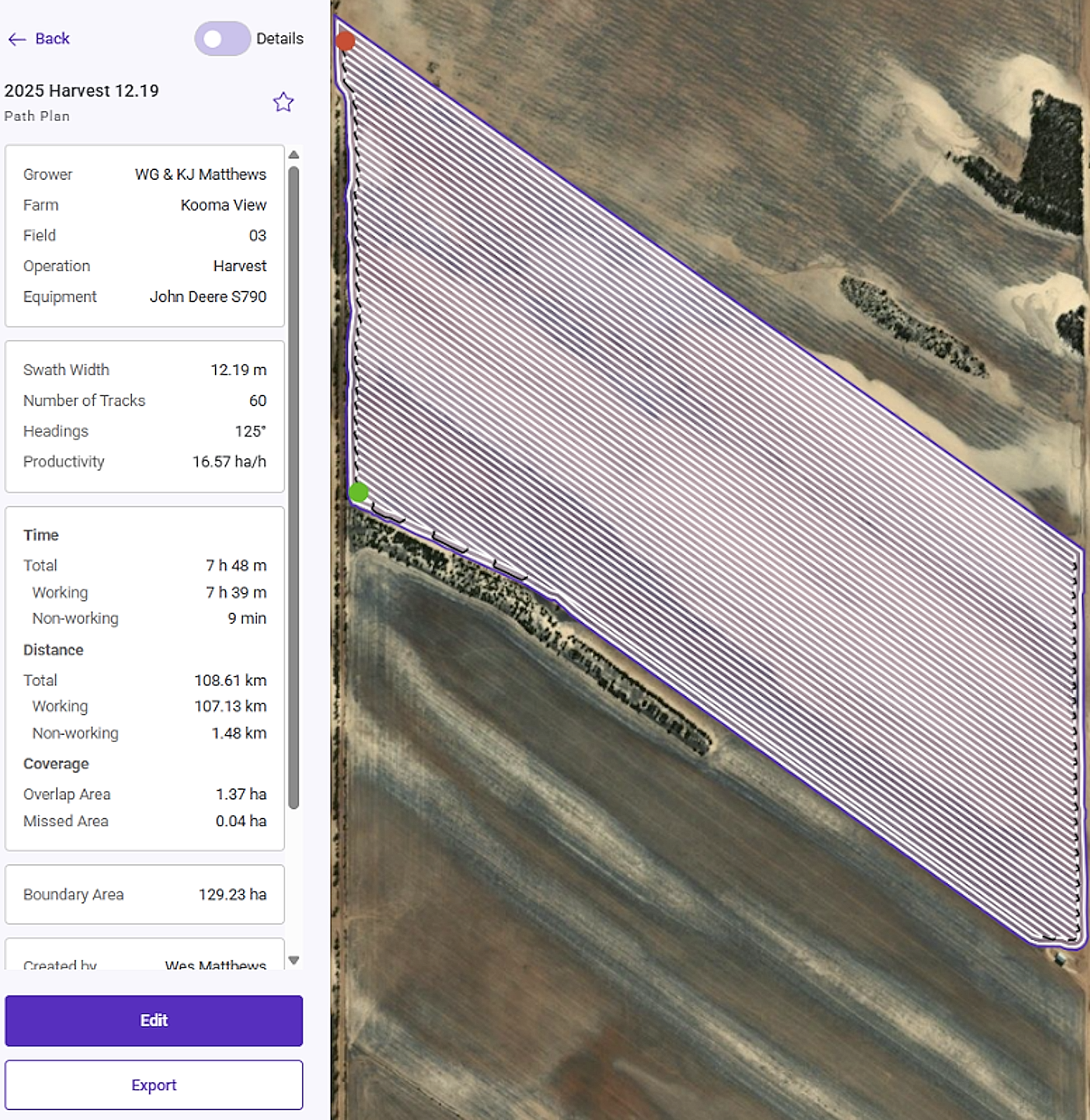
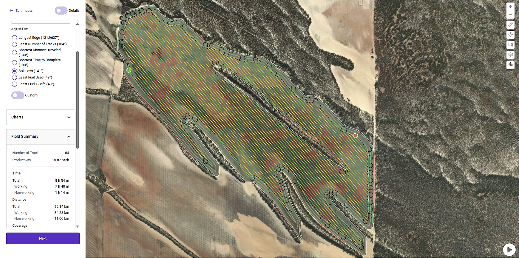
The Matthews, in conjunction with their soil consultant Michael Eyres, began using Launch Pad for fleet planning and field bin placement, as well as using features to redesign their run lines to improve time efficiency. A key finding from the initial simulations was that after uploading their paddock boundary and existing AB headings, Launch Pad was used to identify more efficient AB headings. Paddock Path Plans were created which reduced track numbers in one paddock from 190 to 127 and reduced turning distance by 1.87 kilometres. The new AB line did add an extra 1.82 ha to the overlapped area but assisted to reduce soil erosion, fuel usage and saved 21 minutes overall seeding time.
These gains were only the first step. The team has now progressed to using Launch Pad to simplify the more intricate paddock management decisions around AB heading shifts, soil surface stability management, and fleet planning.
Launch Pad, developed by Verge Ag, is a web-based precision agriculture platform that turns a grower's existing machinery and guidance systems into supervised autonomy. It generates custom GPS-compatible routes based on paddock boundaries, equipment specifications, and operational goals, planning the most effective way for equipment to move across a field. This reduces costly in-cab decisions and improves overall productivity while cutting fuel use, working time, and environmental impact. When combined with autosteer and high-accuracy guidance, operators focus on monitoring rather than steering.
Case Study Snapshot
- Grower
- Wes and Karen Matthews
- Farm
- Kooma View Farming
- Location
- West of Kimba, Eyre Peninsula, South Australia
- Area
- 7,500 ha (1,400 ha problematic sandy soils)
- Crops
- Wheat, barley, lentils
- Soil Consultant
- Michael Eyres, Field Systems
- Agronomist
- Leigh "Megsy" Davis
- Key Challenge
- Wind erosion across dune swale systems
The Challenge
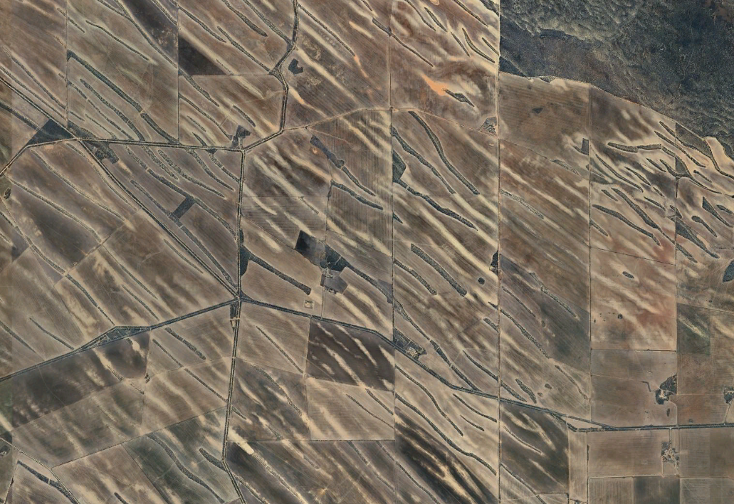
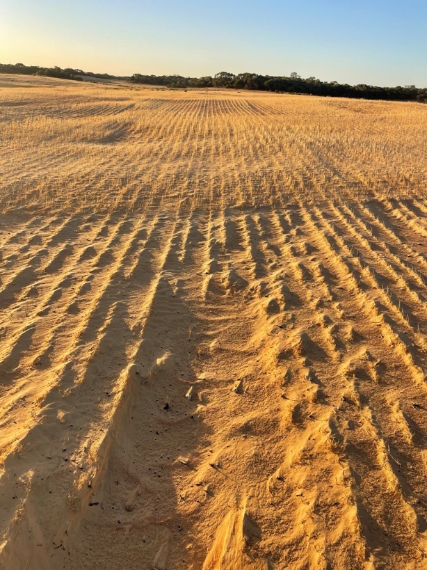
A significant issue the Matthews continue to face is managing operations around dune swale systems, which are landforms that have undergone repeated cycles of erosion and reformation. The higher dunes' sand particles geologically reverted to sandstone over thousands of years before breaking down again, which produces the highly mobile, fine particle sands, usually acting as an often water-repellent sand raft over a seasonally hard-setting sand layer.
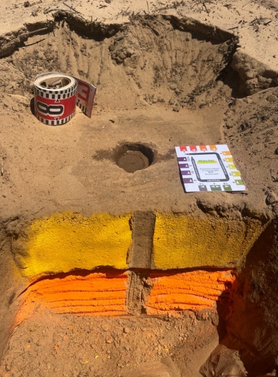
These ancient and ever-changing landforms create challenges, particularly as they run largely perpendicular to the angle of the roads in the area, and as a result, often the longest fence lines (which traditionally dictate AB headings). Therefore, machinery has often had to navigate these on difficult angles. The rising parallel dune formations are managed in many ways at Kooma View, including clay spreading with a scraper, delving and spading, multi-purpose soil surfactants and integrated path planning design.
Such variable soil types have often made it difficult to plan and conduct the farm's soil management. Operations have been influenced by dune position, prevailing winds, leeward effects, pH variation, clay type and volume available, dispersive capacity of clay, and particle size differences. Treating each soil type efficiently requires tailored practices and complex planning, which Launch Pad has the ability to optimise.
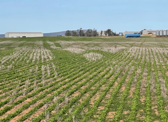
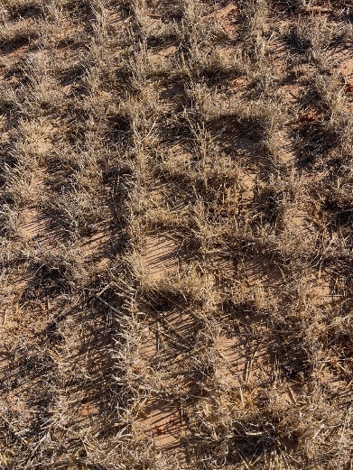
To further complicate farming, the wind changes direction throughout the year, which alters dune shapes and the direction of soil movement and accumulation. During sowing (April to May), weather fronts commonly bring strong westerly winds. If crops are planted east to west, the furrows align with the wind direction, creating "gutterball lines" that allow accelerated wind flow and fine particle carry. This causes sand to mobilise rapidly along the rows, cutting off emerging crops in vulnerable areas, sometimes in a single night.
Another issue of farming on this country is that keeping to the same CTF lines year after year led to churning up and exposure of topsoils, making them increasingly vulnerable to movement from wind.
Efficiencies have been lost in both time and overlap due to the issues in trafficking the various soil types and dune swale land systems. Overlap costs are increasingly significant to businesses considering the rising price of input costs, in particular fertiliser and fuel coming into the 2026 season.
Fleet planning has also been a key area affecting efficiency, particularly around field bin and truck placement. Having the ability to optimise plans to be empty at the end of a paddock for variety changes can be a huge time saving too. The Matthews have identified this as a key area that has potential for improved operational and planning efficiency since the early days of using Launch Pad.
A Shift in Thinking
Focusing on issues relating to soil management, the Matthews identified they needed to change their macroscale thinking ("we can't control nature") to microscale intervention ("control the first centimetre off the ground"), which became central to the strategy of managing difficult soils, such as dune swale land systems. Working with soil erosion scientist John Leys (NSW), the team focused on understanding:
- Peak flux: the wind speed at which sand particles reach maximum movement.
- Critical particle size: grains smaller than 0.84 mm are far more mobile.
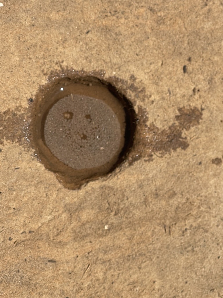
- Height of control: stop the first sand grain moving. Although erosion appears dramatic with dust plumes visually existing 50 metres high, the most effective intervention opportunity occurs within the top 1 cm of soil where particle movement begins. Even tyre tread pattern is critical.
Using Launch Pad
The Matthews and Michael have found Launch Pad to be user-friendly over the years. Pre-populating the platform with their existing paddock maps and AB lines from the John Deere Operations Center made it much easier to begin planning and refining existing AB lines directly within Launch Pad. They felt that the cost of Launch Pad was well worth the benefits it offered their farming systems. At this stage, they estimate they are using only 30 to 40% of the platform's full capability. Another bonus was that the prevailing winds could be avoided when path planning could be done from the comfort of the office rather than a paddock.
The team initially expected to use Launch Pad mainly for paddock-level efficiency such as optimising field bin placement, ensuring boxes emptied at the right time for variety segregations, or for planning fence removals to increase efficiency, reducing erosional risk and preventing weed seed banks along fence lines. For instance, Wes and his staff were able to compare paddock efficiencies if a fence was taken down before the operation was finished. Wes combined two paddocks using this data, saving 206 headland turns and an additional 2.63 hectares on overlap and input expenses.
As the work progressed, the focus shifted, and the system began opening up far broader opportunities than originally anticipated, such as addressing topsoil preservation. These findings were important, as they allowed Launch Pad to assist in designing and quantifying operational changes that worked with the identified system changes that were required.
Altering AB Headings to Combat Soil Movement
In order to reduce repeated traffic on lighter soils at seeding, the Matthews used Launch Pad to assist in redesigning, or shifting, their AB headings. The two main approaches in redesigning Path Plans from original CTF lines were:
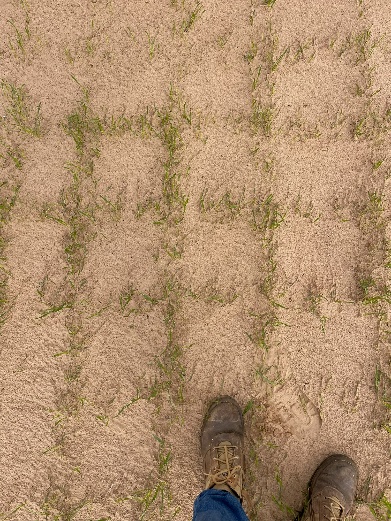
- Diamond hatching (angled at 45°): more plants arresting peak flux of prevailing winds per lineal metre.
- Crosshatching (north to south + east to west): soil stability and ease of management but less intersecting plant numbers.
The goal was to reduce repeated traffic, as well as create a dense "living barrier" that intersected wind paths, disrupting airflow and reducing sand movement around rising dune formations. Based on observed topsoil movement and the subsequent removal of 5 to 7 cm of dune topsoil after sowing, calculations using crosshatching and diamond-hatching methods indicated that the treatment may have prevented the movement and loss of up to 700 t/ha of soil, assuming a soil bulk density of 1.
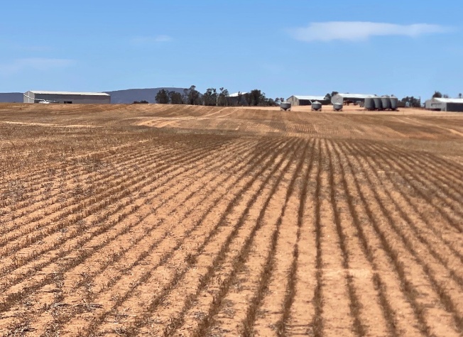
To achieve and then further develop these management concepts, Wes began experimenting with harvesting on an angle. Launch Pad has a feature that allows original headings to be altered by a set number of degrees, which creates a new Path Plan that identifies a route with the least number of tracks, or the fastest time to complete.
Using these features, the team trialled shifts of up to 15 degrees from the original AB lines; however, this angle proved too rough across different soil types and with their header fronts. They ultimately settled on an 8-degree adjustment, which maintained a smooth, continuous flow across the cutter bar and, in combination with the AWS air reel, significantly reduced head and grain losses during harvest. A change of +8° equated to 73 total run lines, while -8° was 81 run lines. Keeping logistics in mind, the team chose the +8° option as it had reduced time to complete and number of runs.
This improvement not only reduced the risk of excessive CTF line travel but also created measurable income gains from lower harvest losses. The double-edged benefit in this instance is improved harvester efficiency and "diamond-crossed" anchored straw residue over summer and the following autumn high erosional risk period.
Launch Pad allowed the team to not only identify and compare these different headings, but the outcomes they had across machinery types and widths across seasonal Path Plans. This allowed metrics to be collected on time requirements, as well as overlap values. The Matthews team found that small tweaks in Launch Pad, such as a degree change, could save up to eight hectares of overlap in total in some paddocks.
Altering Topography and Speed
Launch Pad can ingest elevation (topography) and field layers, allowing machine and run parameters, including target speeds, to be defined. Launch Pad uses these inputs to generate context-aware Path Plans that minimise inefficiency from slopes, dune effects, and awkward paddock geometry.
The Matthews integrated their topography and soil-type layers, generating context-aware machine routes and standardising operation plans in order to reduce planning time and operator error. This was primarily to address the dune-swale landforms on their farm. The Matthews had identified that the dune crests, light sand and non-wetting, required slower machinery speeds to prevent erosion. Swale floors had heavier soil types which supported faster speeds, while mid slopes were identified to suit a speed in between the two. Launch Pad was used to compare and measure different sowing speeds for travel and turning (speed of sowing = speed of growing) across soil types and machinery.
Next Steps
Looking ahead, the team expects to zone soils for different operations and management, refine sowing speeds matched to seeder configuration and soil type, create furrow fracture patterns, and tailor intervention depth (to include press wheel pressure) and seed placement across specific crop types. The Matthews plan to apply Launch Pad tools more directly to these soil management operations.
A clearer understanding of soil dynamics will also allow operations such as spraying and delving to be optimised according to variations in soil moisture, particle size and soil texture, pH, soil water repellency, and seasonal soil movement directional risk.
A key next step is completing high-accuracy mapping of all fence lines at two-centimetre resolution. While much of this work is already complete, some boundaries need verifying or straightening where earlier recordings were less precise. This level of accuracy will be essential for not only Launch Pad accuracy, but integrating emerging technologies such as autonomous drones, field robotics such as Flux or SwarmFarm, and airborne spraying systems.
With aviation experience on the farm, there is particular interest in exploring larger airborne platforms such as a Pelican-class drone sprayer, which will also require highly accurate, ground-truthed boundaries. Once these dynamics are fully understood, the sowing system and erosional risk management can be further optimised.
Building on preliminary Launch Pad results around AB heading selection, the Matthews are now considering using the same 8-degree lines in selected paddocks for sowing, as well as harvesting. By alternating between seeding and harvest lines each year, they aim to continue establishing their diamond-shaped traffic patterns that help disrupt wind pathways, reduce drift, and minimise sand movement across vulnerable dune systems.
Herbicide interactions, row spacing, germination, emergence and early vigour performance also stand to benefit from this more precise approach going into this season.
Conclusion
Despite the progress so far, the Matthews believe they are still only tapping into a fraction of what the Launch Pad platform can deliver.
What began as a tool for fleet planning and field-bin logistics has now expanded into a platform supporting efficiency gains across a wide range of farm operations. Together with their soil consultant Michael Eyres, and working closely with their agronomist and ex-Minnipa researcher Leigh "Megsy" Davis, the Matthews see even greater potential, not only for their own farm but for sharing insights across their wider farming community.
This ongoing collaboration has already extended into soil management, erosion control, and a deeper understanding of the dune-swale system. Here, Launch Pad has helped take a highly complex system and make it manageable by simplifying complex decisions without ignoring the underlying variability.
Acknowledgements
Through the Grain Automate initiative, Grains Research and Development Corporation (GRDC) has partnered with Verge Ag and the Australian Controlled Traffic Farming Association to support the acceleration and adoption of machine automation, autonomy and digital technologies in the Australian grains industry. The research undertaken as part of this project is made possible by the significant contributions of growers through both trial cooperation and the support of the GRDC. The authors would like to thank them for their continued support.
We extend our thanks to Wes Matthews and Michael Eyres for generously sharing their time and information on behalf of their businesses, which made this case study possible. Thank you to Talking CTF for producing the initial podcast of this case study.
Ready to Optimise Your Operations?
Discover how Launch Pad can transform your paddock planning
Get Started Now