Boundary Correction
Field boundaries rarely arrive perfect. Launch Pad runs every boundary through an automatic geometry correction pipeline that detects invalid shapes and repairs them before planning, so path plans are always generated from clean, valid geometry.
Most boundary problems are invisible
Invalid geometry is surprisingly common in real-world boundary data, and most of it cannot be seen on a map: a self-intersection can hide in a single vertex. Most customers never know their boundaries have these issues because Launch Pad corrects them automatically. If you are integrating with the API and wondering why a boundary you read back differs slightly from the one you sent in, this page explains what happened and why.
Where invalid geometry comes from
Manual editing
Drawing a polygon on the map, then appending, deleting, or dragging vertices can introduce self-intersections and overlaps without any visible sign.
Third-party services
Boundaries altered by connected platforms (for example John Deere Operations Center) can come back topologically malformed.
Mixed-content files
Uploaded files sometimes carry stray points, lines, or geometry collections instead of clean polygons.
More than a basic "make valid"
Most GIS stacks repair broken geometry with a single make-valid operation. That resolves the topology error, but it is a blunt instrument with no opinion about what a usable field boundary looks like afterwards. Launch Pad instead applies a sequence of targeted corrections and keeps a general make-valid repair as the fallback for cases the targeted fixes cannot resolve.
Filtering
Points, lines, and other non-area geometry are removed so only polygons move forward.
Splitting
Self-intersecting outer boundaries are split into separate valid polygons instead of discarding part of the field.
Merging
Overlapping or intersecting holes are unioned into a single hole, as the spec requires.
Buffering
Rings are buffered by a small tolerance so holes never share an edge with the outer boundary.
Reconstruction
Holes are subtracted from outer boundaries to rebuild a clean MultiPolygon, clipping any hole that strays outside its shell.
Sliver removal
Stray fragments below a minimum area are dropped, unless they are the only piece of the field.
Normalization
Ring winding follows the GeoJSON right-hand rule and coordinates are flattened to 2D, with any elevation values stripped.
Fallback repair
A general-purpose make-valid repair handles self-intersections and other errors that survive the targeted steps.
What "valid" means
The output of the pipeline is always a valid MultiPolygon, following the polygon and MultiPolygon validity rules of the OGC Simple Features Specification:
- • Every polygon has exactly one exterior ring, and that ring is a valid polygon: a closed line with at least 3 distinct points and no self-intersections.
- • Interior rings, if any, are valid polygons that lie fully inside their exterior ring.
- • Interior rings do not intersect one another; rings that do are merged into one.
Exterior ring (shell)
The outer boundary of a polygon. There is exactly one per polygon.
Interior ring (hole)
An inner boundary cut out of the polygon, such as a slough or rock pile. A polygon can have many holes.
MultiPolygon
A collection of polygons. A field with two separate parcels is one MultiPolygon with two polygons.
Merge
A geometry union operation: combining overlapping shapes into a single shape.
How the pipeline works
-
1
Normalize the input. Only polygonal geometry is kept. Points, lines, and other non-area members of geometry collections are dropped, and exterior rings are extracted.
-
2
Validate every ring. Each exterior polygon is validated in turn, then each interior ring.
-
3
Repair self-intersections. Self-intersecting exterior rings are split into separate polygons. Intersecting interior rings are merged. If a merge does not resolve an intersection inside the main shell, the polygon falls back to a general make-valid repair.
-
4
Buffer the rings. Every ring is buffered by a small tolerance so interior rings never end up sharing an edge with an exterior ring.
-
5
Rebuild the result. Interior rings are subtracted from exterior rings to form the final valid MultiPolygon. Holes that fall outside a shell are clipped to the shell that contains them, and a hole that lies entirely outside every shell is kept as its own polygon rather than discarded.
If the input cannot be salvaged, for example when nothing remains once the invalid parts are removed, Launch Pad reports the failure instead of inventing a shape, and every correction step is logged so the outcome can be audited.
Note: Processing happens in a projected coordinate system so distances are in meters, and the result is converted back to WGS84. That is why buffer tolerances are expressed in meters rather than degrees.
Before and after examples
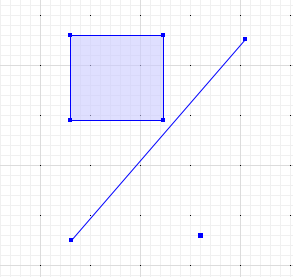
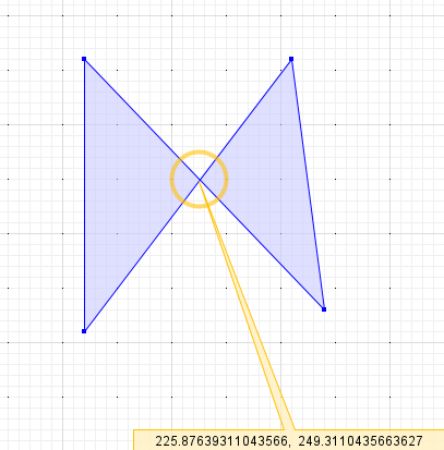
Five representative cases of malformed input geometry (blue) and the corrected output (yellow). Expand the WKT to see the exact coordinates.
Case 1: Mixed geometry types
The input is a GeometryCollection rather than a MultiPolygon, and it contains a LineString and a Point alongside the actual polygon. The line and point are removed, and the exterior ring is extracted from the polygon.
Input WKT
GEOMETRYCOLLECTION (LINESTRING (131 125, 305 326),
  POINT (260 130),
  POLYGON ((130 330, 223 330, 223 245, 130 245, 130 330)))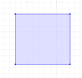
Result WKT
MULTIPOLYGON (((130 330, 223 330, 223 245, 130 245, 130 330)))Case 2: Self-intersecting boundary
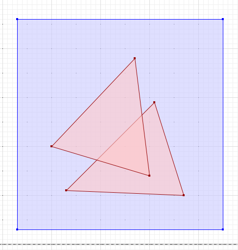
The exterior ring crosses itself, forming a bowtie. This is not a valid polygon, and many planners would reject it or silently drop one lobe. The cleaner splits the ring at the crossing point into two valid polygons, preserving the whole drawn area.
Input WKT
POLYGON ((120 110, 120 360, 340 130, 310 360, 120 110))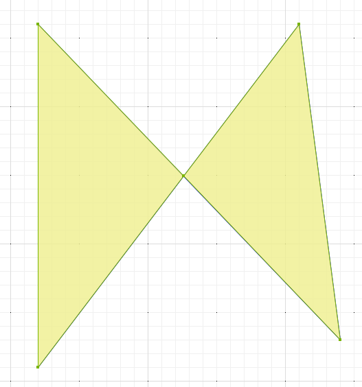
Result WKT
MULTIPOLYGON (((120 110, 120 360, 225.87639311043566 249.3110435663627, 120 110)),
  ((225.87639311043566 249.3110435663627, 310 360, 340 130, 225.87639311043566 249.3110435663627)))
Case 3: Overlapping holes
Two interior rings intersect each other, which the spec forbids. The holes are merged into one, and the polygon is recreated with the single combined hole.
Input WKT
-- outer boundary
POLYGON ((130 460, 550 460, 550 30, 130 30, 130 460))
-- inner boundary
MULTIPOLYGON (((230 110, 410 290, 470 100, 230 110)),
  ((370 380, 400 140, 200 200, 370 380)))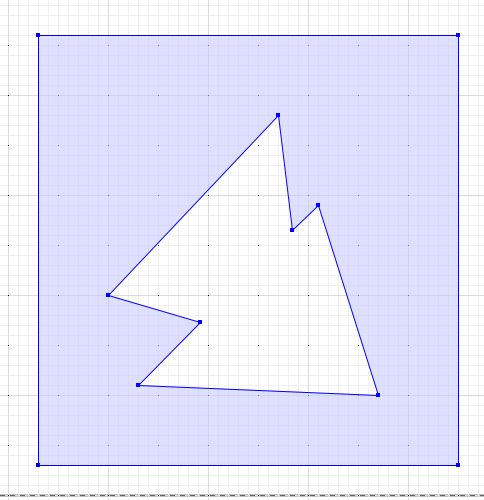
Result WKT
MULTIPOLYGON (((130 460, 550 460, 550 30, 130 30, 130 460),
  (292.3076923076923 172.30769230769232, 200 200, 370 380, 384.44444444444446 264.44444444444446, 410 290, 470 100, 230 110, 292.3076923076923 172.30769230769232)))
Case 4: Overlapping outer rings
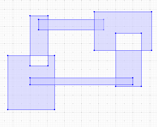
Several exterior rings overlap and self-intersect, together enclosing an empty pocket. The rings are buffered and merged into a single outline, and the enclosed pocket is preserved as a proper hole.
Input WKT
MULTIPOLYGON (((107 153, 134.3 153, 134.3 121.6, 107 121.6, 107 153),
  (120 147, 120 176.2, 130.5 176.2, 130.5 147, 120 147)),
  ((125 174, 163 174, 163 168, 125 168, 125 174)),
  ((157.5 178.6, 191 178.6, 191 156, 157.5 156, 157.5 178.6),
    (170 166, 185 166, 185 135, 170 135, 170 166)),
  ((180 140, 180 136, 120 136, 120 140, 180 140)))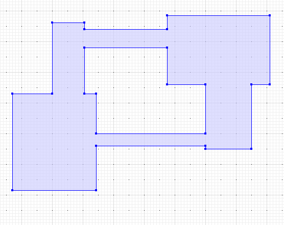
Result WKT
MULTIPOLYGON (((170 136, 134.3 136, 134.3 121.6, 107 121.6, 107 153, 120 153, 120 176.2, 130.5 176.2, 130.5 174, 157.5 174, 157.5 178.6, 191 178.6, 191 156, 185 156, 185 135, 170 135, 170 136),
  (130.5 168, 130.5 153, 134.3 153, 134.3 140, 170 140, 170 156, 157.5 156, 157.5 168, 130.5 168)))
Case 5: Holes outside the shell
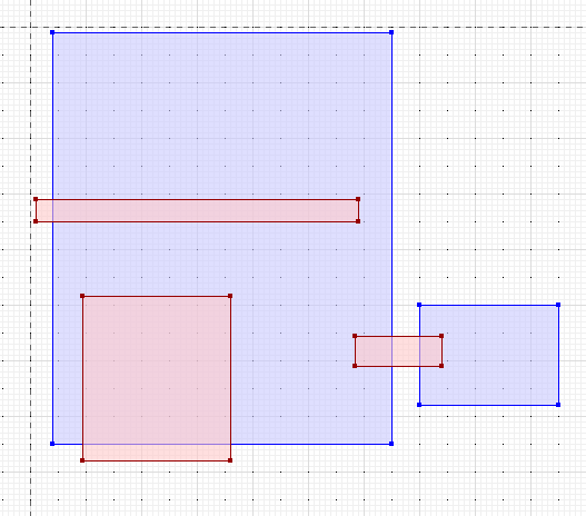
The field has two separate outer rings, and the holes do not respect them: one hole spans the gap between the two shells and others poke past the edges. Each shell is rebuilt separately and every hole is clipped to the shell that contains it, with a small buffer so no hole shares an edge with its shell.
Input WKT
-- outer boundary
MULTIPOLYGON (((104 199, 165 199, 165 125, 104 125, 104 199)),
  ((170 150, 195 150, 195 132, 170 132, 170 150)))
-- inner boundary
MULTIPOLYGON (((158.44444444444446 144.33333333333334, 174 144.33333333333334, 174 139, 158.44444444444446 139, 158.44444444444446 144.33333333333334)),
  ((101 169, 159 169, 159 165, 101 165, 101 169)),
  ((136 122, 109.44444444444444 122, 109.44444444444444 151.55555555555554, 136 151.55555555555554, 136 122)))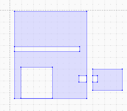
Result WKT
MULTIPOLYGON (((170 150, 195 150, 195 132, 170 132, 170 150),
  (170.0010000000475 144.33333333333334, 174 144.33333333333334, 174 139, 170.0010000000475 139, 170.0010000000475 144.33333333333334)),
  ((104 199, 165 199, 165 125, 104 125, 104 199),
    (109.44444444444444 125.0010000000475, 109.44444444444444 151.55555555555554, 136 151.55555555555554, 136 125.0010000000475, 109.44444444444444 125.0010000000475),
    (164.9989999999525 139, 158.44444444444446 139, 158.44444444444446 144.33333333333334, 164.9989999999525 144.33333333333334, 164.9989999999525 139),
    (104.0010000000475 169, 159 169, 159 165, 104.0010000000475 165, 104.0010000000475 169)))