
Feature Update: New Homepage
By AJ
Homepage improvements
If you have logged into Launch Pad™ over the few weeks you may have noticed things are looking a little different. In addition to releasing a bunch of new features we have also set our team towards making the user experience better, and more streamlined.
Path Planner™ is the first step to unlocking your optimal guidance lines, increasing operator efficiency, and many additional benefits that come from pre-planing your farm operations. Kicking off this workflow should not be frustrating or difficult. Although our old dashboard view answered a bunch of questions, it caused just as many, leading to a potentially frustrating and confusing experience for users. This is why we have decided to forgo the dashboard for now, and concentrate on a more streamlined approach when initiating Path Planner.
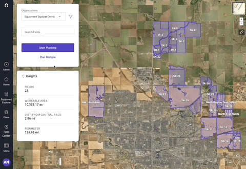
The new homepage features visual changes to keep our styling and design consistent across the app. Fields names are now displayed on the boundary to help users associate boundaries to list items, and selected field insights are displayed for reference. Other enhancements include the list view, improved multi-select, and the insights panel.
Farm software user types
In our experience there are three types of users when it comes to farm management information systems.
Type 1: Map Interactors
The first user is the type that interacts with the map. Clicking on field boundaries, panning to find fields, and using legends to navigate. These users would be completely fine with only a map view, and may or may not have a coherent grower, farm, field structure.
Type 2: List View Users
The second type of user that we see in agriculture software is a person who mainly interacts with the list view. These users look for specific names, and diligently manages their grower, farm, field structure. Depending on the country of origin, the names of fields can have a certain structure, and in some cases may only be a number.
Type 3: Dynamic Users
Next, we have the dynamic user segment. These individuals exhibit diverse interaction patterns with their digital farm twin. Utilizing either the map or the list interface, and positioned along a spectrum from organized to disorganized. Enhancing organization through tailored features tends to be particularly beneficial for this user group.
Hopefully all three user types can find something to enjoy with our new homepage.
Path Planner on a single field
At its core Path Planner is a precision agriculture software tool that helps operators, farm managers, and consultants achieve more efficiency in the field. This starts with analyzing individual fields, and optimizing for different parameters such as heading, time, travel distance, and overlap.
Map Interaction
Single field path planning can be initiated directly from the map view of the homepage. A simple click inside the field boundary on the new homepage brings up the field summary widget. From here you can select "New Path Plan" to enter the Path Planner interface.

List View
Getting started path planning with the list view is as simple as selecting the giant purple call to action labeled: "Start Planning". This will open the field list, and the user can then pick a field from the alphabetically sorted list. The map view will zoom to show the selected field. Confirm the selection by clicking on the "Path Plan" button.

Path Planning on Multiple Fields
In many farming operations, the individuals responsible for planing the movement of equipment want to apply the same path planning parameters to multiple fields. This could be for various reasons, but one of the common ones is that a certain portion of fields are relatively square or rectangular. These fields can be planned relatively the same, and the most efficient route is fairly straight forward. The more complex a boundary, the more benefit can be unlocked by experimenting with path plan comparisons.
If you are blessed with less complex fields, or diligently work to keep your fields in shape, multiple field planning can help you save some time during the planning process.
Clicking the "Plan Multiple" button on the main panel will open up the list view. From here the user can either use the check boxes next to each field name or multi-select via the map. These two actions both have the same effect, and increase the field count on the Path Plan button. Once all desired fields are selected hit the big path plan button to kick off the workflow.
As great as it is to have an easy button for path planning, we recommend taking a second look at all your saved plans via the plans page. There might be situations where straight edge selection might be better. Maybe rotating your inner tracks by a degree or two might even be your optimal.
Continuous improvement
Verge Ag is committed to providing delightful and meaningful experiences within our app. This means that as hard as it is to admit, we don't get it right the first time. With your help we learn and grow. This new version of the home screen is proof we are trying uphold this commitment.
Login today to experience the new homepage yourself.